


The Wonderful Views of San Mateo, Rizal – Photo by Rene Villarta
The trails in San Mateo is a roller coaster ride. It has lung-busting ascents and has long adrenaline-pumping descents. The beauty of the trail is that at its peak, you get a view of the mountains and at times, even a sea of clouds. At the bottom of the trail, you get the rivers to admire. It would have your eyes feasted, your heart-rate beating faster and your legs getting stronger.
Read About:
- Incoming: Rizal Mountain Run
- Climbing the 12 Peaks of Mt. Batulao
- Cordillera Mountain Run
- #TaleOfTheTrail Dragons Back (Hong Kong)
- #TaleOfTheTrail Camp John Hay Trails (Baguio City)
- #TaleOfTheTrail Mount Talamitam (Nasugbu, Batangas)
- #TaleOfTheTrail Mount Cabuyao (Tuba, Benguet)
- #TaleOfTheTrail Maysawa Trail (Tanay, Rizal)
- #TaleOfTheTrail Mount Kinabalu (Kota Kinabalu, Sabah, Malaysia)
- #TaleOfTheTail Mount Marami (Maragondon, Cavite)
- #TaleOfTheTrail Lantau Peak (Lantau Island, Hong Kong)
- #TaleOfTheTrail Lion Rock (New Territories, Hong Kong)
- #TaleOfTheTrail Ampucao – Sta Fe Trails (Ampucao, Itogon, Benguet)
#TaleOfTheTrail

I was so excited when I got invited to join the Recon of Rizal Mountain Run because it will be another trail adventure for me. I also see the race as something newbies, experienced trail runners and even elite runners can learn from. The meet up was at 4:30 am at UP Diliman, where we had several 4×4 bringing us to the start of the recon. The 4×4 ride was an adventure on its own as we got shaken all throughout the ride as we passed through the rough roads. The plan was to do a 13 kilometer run, which was a reverse loop of the actual run. From Casile New Road, we would be making our way to the start area in Sandugo Basekamp. They planned a rolling course with moderate ascents and descents for us.
The Map and Elevation

Map is powered by Suunto Ambit 3 Sports and Movescount
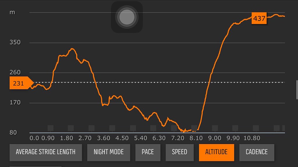
Elevation Profile is Powered by Suunto Ambit 3 Sports and Movescount
The trek starts at Casile New Road with a slight rolling terrain on the first kilometer. The trail follows Casile New Road and shifts on a long ascent of about 120 meters on the second kilometer. The trail goes on a long descent in the next 4 and a half kilometer worth about 300 meters of elevation. There’s about a kilometers worth of descent to Bajo River and another half a kilometer exploring two rivers before starting the PG climb at kilometer 8. The steep climb at PG covers about 350 meters of elevation spread out over 2 kilometers. The trek then shifts to the road with more than 2 kilometers of rolling terrain heading to Pintong Bukawe.
Trekking San Mateo Rizal Trail

Starting on dirt roads
The trail started at Casile New Road, which had rugged fire trails used by the local community here. You get a mix of dirt roads, rocks and grasslands across the trail. The trails are not technical but the ascent can be a challenge. The plan was to do the Casile New Road until Pintong Bukawe covering about 12-13 kilometers. The good part about the recon is that we had a chilly weather throughout.

The lovely Trail Masters Majo and Iris.
We got started on fire trails, which had moderate ascent and descents. Majo and Iris led the pace so that means we’re moving at a faster pace. It was a good thing we had rest stops to hydrate as the 4×4 was shadowing us on the trail. There were peeks of the mountains along the trail as well as rock formations.

Rock Formations along the trail.
The second kilometer was a crawlfest as we had about 120 meters worth of elevation to deal with. It was a challenge but we kept this part at walking pace and would rest shortly on flatter parts of the climb. Despite the tough climb, it was nice to see the surrounding mountain ranges in the area. I’m learning a lot here on how to manage my energy on the climbs here.

You just got to admire the beauty around you.
After the climb in the second kilometer, the course goes on a descent. It was an exhilarating ride downhill. I went with the faster group since when it comes to group runs, it’s the last runner who gets the shortest rest #TrueStory. We got treated to one of the best sites of the trail here with the vantage point of the mountains and clouds that surrounds it.

Selfie Spot.
The next 4 and a half kilometers was a really wild and long descents with a few climbs in between. I’m not a daredevil when it comes to downhill terrains. Since this is on wide roads and the steepness was just fine, I went with the group at a fast pace. It’s like unleashing the kid in me as I went carefree on the drops. The only rest we had on that stretch were the climbs, the stops when the 4×4 is in the area and of course, the photo-opportunities.

Gotta love the view from the top.
It was a long descent and at same parts, I was pacing with Majo, Iris, Jeff of Pinoyfitness, Adrian of Takbo.PH and in some areas was pacing with Ronald of Ahon. The other runners were Jael, Cookie and Rene and Jun. I felt braver on the descent after doing this long stretch of downhills. I think the longer you are in the trail, the more comfortable you get.

Running is Fun with Jeff Lo of Pinoyfitness and Ronald of Ahon. Photo by Leonard Reyes
What I like about this stretch is that it was not pure downhill, there were stretches that you had to slow down because of some short climbs. It sorts of helps you balance the effort throughout the trail. I had to do some terrain and elevation management as I went on to cruise on the descents and recover on the inclines.

Easy way or the hard way??? Photo from Rene Villarta
At kilometer 6.5, we had to regroup as we were given the option of going on a moderate climb or go downhill to the Bajo River and have climb the steep PG trail since I requested to do a river crossing. I said, let’s do the river and just think about the consequence later. Deep in my mind, I knew that it was choosing the harder option but I’m sure we’ll find a way to surpass that part… I hope.

I love Rivers – Photo by Jeff Lo
It was another sweet descent going to the river for the next kilometer. The river was maybe knee to waist deep but had strong currents. There were stones which you can step on at some part but for the rest you just got to get wet. I love rivers and being wet is just the fun side of the trails. We had to cross two rivers before we could get to the climb part.

Another River to Cross
At about kilometer 8, it was time to climb again and this wasn’t an easy climb. If you could see in the elevation profile, it’s almost a straight line upwards covering 350 meters of elevation over the next two kilometers. Climbing is one of my weak points. This is the point where I got to realize to “be careful what you wish for”. I started the climb with the lead pack but I had to pull back since I had to catch my breath from time to time.

Exhausted
I was climbing solo in the middle of the lead pack and the next group of runners. It was exhausting to climb as every time you see an end to the climb, you’ll get the next set of climbs once you reach that area. Yes, there is such a thing as forever. Since I was on solo mode at this point, I then had to add mental toughness. I figured just to take the climb 100 to 200 steps at a time before I take 30 seconds to rest. Little by little, I was covering the 2 kilometers worth of climbs. I have to say that I am slowly increasing my climbing resistance.

When times are hard, enjoy the views.
I am now about to reach the end of the climb, half hoping that I didn’t take a wrong turn. There were two major forks towards the top of the climb. The first one, I asked a local who was going down. He told me that the two roads would lead to the same direction but the one he took was shorter but steeper and he didn’t see any of my fellow runners. I took the easier but longer route. I met another local to confirm that they did pass by the same route. The second had a wide road and a trail option. I went on with the wide road and in the middle of the road I got a confirmation that the road would intersect with the trail. Before I got off the wider road, I had to contend with dogs ganging up on me. One was about to attack me so I picked up a stone and through it near the dog just to scare it. I took the moment the dog backed away for me to proceed.
I was out of the trails and into the Pintong Bukawe part. It was a good thing I saw the group of 4 x 4 vehicles and Aldean as I exited the trail area. Aldean told me to just follow the road and at the end of the road would be the Sandugo Basekamp. I thought it was just a short road so I was proceeding cautiously for fear of missing the Basekamp. About a kilometer of walking, I asked directions again and they told me that it was still more than a kilometer away. I started to run again and finally reached the Basekamp. That was a really great adventure!!!

Loved the #TaleOfTheTrail Join the Race by clicking on the Rizal Mountain Run Icon above for details.
Outfit of the Trail

- Top: Berghaus with #TaleOfTheTrail Design by Breakout Design
- Shorts: Nike
- Shoes: Brooks Pure Grit 4
- GPS Watch: Suunto Ambit 3 Sports
- Eyewear: Oakley
- Calf Sleeves, Arms Sleeves, Cap, Hydration Bag – Under Armour
- Gaiters – Ahon.PH
- Socks – Features
- Camera: GoPro Hero 3+
48 Responses to #TaleOfTheTrail Casile / Bajo River / PG / Pintong Bukawe Trails (San Mateo, Rizal)